broc2

tosan
User

Length
18.1 km

Max alt
1069 m

Uphill gradient
793 m
Km-Effort
29 km

Min alt
464 m

Downhill gradient
781 m
Boucle
Yes
Creation date :
2025-03-02 13:50:37.2
Updated on :
2025-03-02 13:50:40.397
6h30
Difficulty : Very difficult

FREE GPS app for hiking
 SityTrail
IGN / Geographical institutes
SityTrail Plus
The world is yours!
About
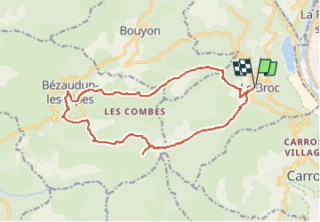
Trail Walking of 18.1 km to be discovered at Provence-Alpes-Côte d'Azur, Maritime Alps, Le Broc. This trail is proposed by tosan.
Positioning
Country:
France
Region :
Provence-Alpes-Côte d'Azur
Department/Province :
Maritime Alps
Municipality :
Le Broc
Location:
Unknown
Start:(Dec)
Start:(UTM)
352665 ; 4852336 (32T) N.
Comments